Introduction
This circular route is proposed with several descent options and is not suitable for all audiences. It includes sections with steep climbs and some rocky stretches on the way down. It can be done on foot or by bicycle if you have an intermediate to advanced level.
The serra de Montbaig, known by many as Sant Ramon Mountain, is one of the places from which you can enjoy some of the best views over the Baix Llobregat.
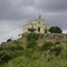
In addition to the landscapes, along the old camí de la Verdera you will cross forests, discover natural and rural heritage elements and, at the very top, the popular Ermita de Sant Ramon, built in the 19th century.
We recommend the Local Natura App to do this route. Download it for free here:
Apple store Google Play-
TypologyTime Circular
-
DifficultyMedian
-
Duration2 hours 55 minutes
-
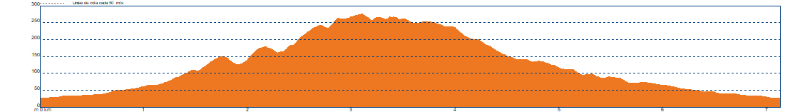
Slope300.00 meters
-
Distance7.10 km
-
ThemeFlora and faunaLandscaping
-
ActivityBy footBy bike
-
Rating
Slope graph
Description
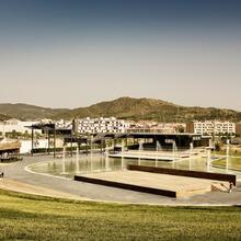
The itinerary starts at Torre-roja Park, next to the Baseball Glove Sculpture, created in 1992. We head north and, at the skate park, turn right to continue through the Can Picó area, passing next to the baseball and softball fields until crossing Avinguda de la Fraternitat.
We take the track signposted towards Sant Ramon along the camí de la Verdera. We continue uphill and soon reach the junction with the camí d’en Vellaca. At this point we find the fig orchard, wine presses and the forn d’en Vellaca as heritage elements. We continue straight uphill alongside the torrent de la Verdera.
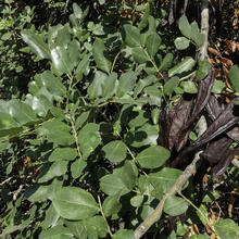
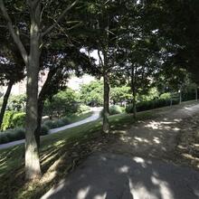
Among oaks, holm oaks and the pine forest of the bosc del Cònsol, the path begins to climb. Inside the forest, we see small dry-stone walls, evidence of former agricultural activity. The scattered carob trees are further proof of this past.
Leaving the forest, always following the main track, we come across a recreation of a beautiful dry-stone vineyard hut, an initiative of the Tres Torres de Viladecans group. From here on, the path zigzags with steep climbing sections. The forest gives way to a dense maquis of large shrubs.
The views improve noticeably, but the path is demanding, especially if you are cycling, as you may need to push the bike on some sections.
On one of the bends, we reach a flat area with a rock cutting and a bench. Just after this point, a descending path branches off. We are at the head of the torrent de Can Menut, and the descending path corresponds to the sports route that runs along the camí de Can Menut. This is a clear example of how active and healthy lifestyles are promoted in Viladecans, which is also part of the Active Running Cities network.
We continue the ascent and only the steepest section up to the hermitage remains. We arrive from the rear, so a short stop just before reaching the top allows us to rest and enjoy the landscape looking north. The eastern foothills of the serres de l’Ordal and the Garraf descend towards the Llobregat Valley.
At the top of Sant Ramon, there is a picnic area, an unregulated water fountain and a spacious square from which we can enjoy views over the entire Llobregat Delta. This is a good place to eat, drink water, enjoy the privileged views and decide on the descent. There are three options: follow the track along the Montbaig ridge, which includes a steep and loose-stone section; return by the same route used for the ascent; or descend until connecting with the camí de Can Menut and follow the sports circuit.
In all cases, the descent must be done with great care, as it is easy to slip. Below the Montbaig ridge, we gently turn westwards, between carob fields, along the camí de les Oliveretes until reaching the camí de la Verdera, which leads us back to the first junction with the camí d’en Vellaca. From here, we retrace our steps back to Torre-roja.
Tips
ROUTE
The ascent via the camí de la Verdera is signposted.
Read the description to choose among the different descent options from Sant Ramon
There are sections with steep climbs and, later, steep descents.
WATER
Bring water from home.
There is an untreated water fountain at the top of Sant Ramon.
PRECAUTIONS
The ascent is very demanding and the descent delicate.
On foot, the climbs are steep. Take care on the descents to avoid slipping.
Respect the natural environment and private property.
Do not climb on the dry-stone huts.
WEATHER
Avoid windy days; at the top of Sant Ramon it can be very unpleasant.
On cloudy or foggy days, the views cannot be enjoyed.
Be careful during the hottest hours on warm days.
TERRAIN
Wide, compacted track with sections of loose stone and steep gradients.
The lower paths among carob trees may be muddy after rainfall.
EQUIPMENT
Camera and binoculars to enjoy the views.
Hiking poles can be useful.
Basic safety equipment (helmet and gloves) and tools (for puncture repair) if cycling.
OTHER FACILITIES
Landscape interpretation exhibition at the top of Sant Ramon, with panels and a model.
Monitoring of raptor migration in late summer and autumn.
Bar (not always open) and picnic tables.
Check information on organised environmental activities and bird migration monitoring in autumn.